Crescent Saturn

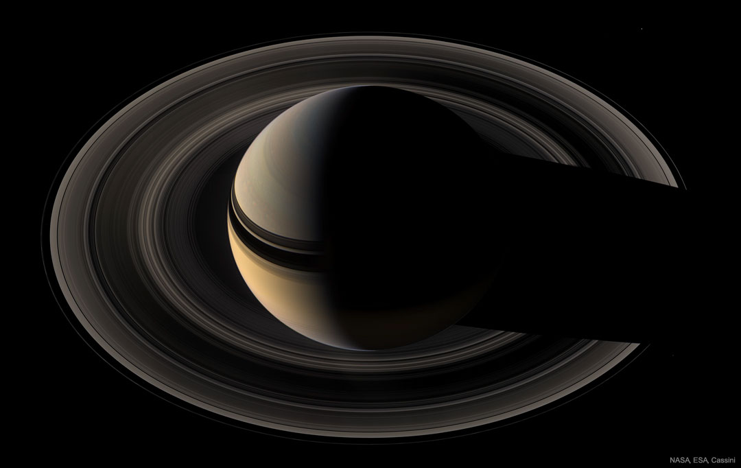
Saturn never shows a crescent phase — from Earth. But when viewed from beyond, the majestic giant planet can show an unfamiliar diminutive sliver. This image of crescent Saturn in natural color was taken by the robotic Cassini spacecraft in 2007. The featured image captures Saturn’s majestic rings from the side of the ring plane opposite the Sun — the unilluminated side — another vista not visible from Earth. Pictured are many of Saturn’s photogenic wonders, including the subtle colors of cloud bands, the complex shadows of the rings on the planet, and the shadow of the planet on the rings. A careful eye will find the moons Mimas (2 o’clock) and Janus (4 o’clock), but the real challenge is to find Pandora (8 o’clock). Saturn is now nearly opposite from the Sun in the Earth’s sky and so can be seen in the evening starting just after sunset for the rest of the night. [via NASA] https://ift.tt/2NEYFRk

8 Minute and 30 Second Eclipse

The total phase of the July 2nd solar eclipse lasted about 4 minutes and 30 seconds at the point of maximum eclipse. On the surface of planet Earth, that was about 600 nautical miles north of Easter Island in the Southern Pacific Ocean. But from 37,000 feet above, on a charter flight intercepting the Moon’s shadow, the Moon could be seen to completely block the Sun for about 8 minutes and 30 seconds. With a tailwind at the mid-eclipse intercept point, the plane was traveling around 488 nautical miles per hour chasing along the Moon’s shadow track. From above the clouds this wide-field image of the totally eclipsed Sun and shimmering solar corona over the wing records the spectacular view from a window seat on the sunward side of the aircraft. [via NASA] https://ift.tt/2xvXhFF

La Silla Eclipse Sequence

The road to the high mountaintop La Silla Observatory in the Chilean Atacama Desert also led in to the path of July 2nd’s total solar eclipse. Recorded at regular intervals before and after the total eclipse phase, the frames in this composite sequence include the moment the Moon’s dark shadow fell across some of planet Earth’s advanced large telescopes. The dreamlike view looks west toward the setting Sun and the approaching Moon shadow. In fact La Silla was a little north of the shadow track’s center line, so the region’s stunning, clear skies are slightly brighter to the north (right) in the scene. [via NASA] https://ift.tt/2JdtRTC

In the Shadow of the Moon

On July 2 denizens of planet Earth could stand in the Moon’s dark umbral shadow during South America’s 2019 total solar eclipse. It first touched down in the Southern Pacific Ocean, east of New Zealand. Racing toward the east along a narrow track, the shadow of the Moon made landfall along the Chilean coast with the Sun low on the western horizon. Captured in the foreground here are long shadows still cast by direct sunlight though, in the final moments before totality began. While diffraction spikes are from the camera lens aperture, the almost totally eclipsed Sun briefly shone like a beautiful diamond ring in the clear, darkened sky. [via NASA] https://ift.tt/2FQcOVu

Robotic Dragonfly Selected to Fly Across Titan

If you could fly across Titan, what would you see? To find out and to better explore this exotic moon of Saturn, NASA recently green-lighted Dragonfly, a mission to Titan with plans to deploy a helicopter-like drone. Saturn’s moon Titan is one of the largest moons in the Solar System and the only moon known to have a thick atmosphere and changing hydrocarbon lakes. After development, building, testing, and launch, Dragonfly is currently scheduled to reach Titan in 2034. The featured animated video envisions Dragonfly arriving at Titan, beginning its airborne exploration, landing to establishing a radio link back to Earth, and then continuing on to another trans-Titanian flight. It is hoped that Dragonfly will not only help humanity better understanding Titan’s weather, chemistry, and changing landscape, but also bolster humanity’s understanding of how life first developed on our young Earth. [via NASA] https://ift.tt/2Yt4pP5

The Big Corona

Most photographs don’t adequately portray the magnificence of the Sun’s corona. Seeing the corona first-hand during a total solar eclipse is unparalleled. The human eye can adapt to see coronal features and extent that average cameras usually cannot. Welcome, however, to the digital age. The featured central image digitally combined short and long exposures that were processed to highlight faint and extended features in the corona of the total solar eclipse that occurred in August of 2017. Clearly visible are intricate layers and glowing caustics of an ever changing mixture of hot gas and magnetic fields in the Sun’s corona. Looping prominences appear bright pink just past the Sun’s limb. Faint details on the night side of the New Moon can even be made out, illuminated by sunlight reflected from the dayside of the Full Earth. Images taken seconds before and after the total eclipse show glimpses of the background Sun known as Baily’s Beads and Diamond Ring. Tomorrow, a new total solar eclipse will be visible from parts of South America. [via NASA] https://ift.tt/2NoGUW8

Virtual Flight over Asteroid Vesta

What would it be like to fly over the asteroid Vesta? Animators from the German Aerospace Center took actual images and height data from NASA’s Dawn mission when it visited asteroid Vesta a few years ago and generated a virtual movie. The featured video begins with a sequence above Divalia Fossa, an unusual pair of troughs running parallel over heavily cratered terrain. Next, the virtual spaceship explores Vesta’s 60-km Marcia Crater, showing numerous vivid details. Last, Dawn images were digitally recast with exaggerated height to better reveal Vesta’s 5-km high mountain Aricia Tholus. The second largest object in the Solar System’s asteroid belt, Vesta is the brightest asteroid visible from Earth and can be found with binoculars. Using Vesta Trek, you can explore all over Vesta yourself. [via NASA] https://ift.tt/2IYbQIw

M83: The Thousand Ruby Galaxy

Big, bright, and beautiful, spiral galaxy M83 lies a mere twelve million light-years away, near the southeastern tip of the very long constellation Hydra. Prominent spiral arms traced by dark dust lanes and blue star clusters lend this galaxy its popular name, The Southern Pinwheel. But reddish star forming regions that dot the sweeping arms highlighted in this sparkling color composite also suggest another nickname, The Thousand-Ruby Galaxy. About 40,000 light-years across, M83 is a member of a group of galaxies that includes active galaxy Centaurus A. In fact, the core of M83 itself is bright at x-ray energies, showing a high concentration of neutron stars and black holes left from an intense burst of star formation. This sharp composite color image also features spiky foreground Milky Way stars and distant background galaxies. The image data was taken from the Subaru Telescope, the European Southern Observatory’s Wide Field Imager camera, and the Hubble Legacy Archive. [via NASA] https://ift.tt/2KMtX6K

A Solstice Night in Paris

The night of June 21 was the shortest night for planet Earth’s northern latitudes, so at latitude 48.9 degrees north, Paris was no exception. Still, the City of Light had an exceptionally luminous evening. Its skies were flooded with silvery night shining or noctilucent clouds after the solstice sunset. Hovering at the edge of space, the icy condensations on meteoric dust or volcanic ash are still in full sunlight at the extreme altitudes of the mesophere. Seen at high latitudes in summer months, stunning, wide spread displays of northern noctilucent clouds are now being reported. [via NASA] https://ift.tt/2X5OaWD

The Longer Days

This persistent six month long exposure compresses the time from solstice to solstice (December 21, 2018 to June 16, 2019) into a single point of view. Dubbed a solargraph, the unconventional picture was recorded with a tall, tube-shaped pinhole camera using a piece of photographic paper. Fixed to a single spot at Casarano, Italy for the entire exposure, the simple camera continuously records the Sun’s daily path as a glowing trail burned into the photosensitive paper. Breaks and gaps in the trails are caused by cloud cover. At the end of the exposure, the paper was scanned to create the digital image. Of course, starting in December the Sun trails peak lower in the sky, near the northern hemisphere’s winter solstice. The trails trails climb higher as the days grow longer and the June 21st summer solstice approaches. [via NASA] https://ift.tt/2Lm3xb9